


Political Empowerment of Women (in Local Government)
Sreepur
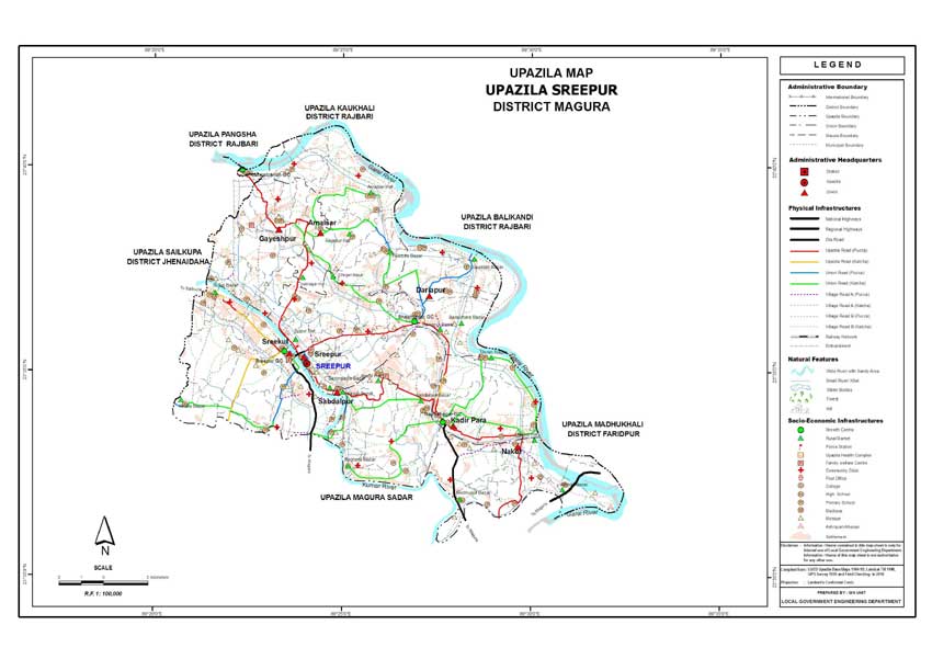
Upazila
Sreepur Upazila (MAGURA district) with an area of 179.14 sq km, is bounded
by PANGSHA and BALIAKANDI upazilas on the north, MAGURA SADAR upazila
on the south, MADHUKHALI and Baliakandi upazilas on the east, SHAILKUPA
upazila on the west. Main rivers are Gorai, Kumar and Mara Kumar; Gazari
Beel and Goaldaha Baor are notable.
Sreepur (Town) consists of two mouzas. The area of the town is
3.11 sq km. It has a population of 4152; male 51.13%, female 48.87%;
population density per sq km is 1335. Literacy rate among the town people
is 42.4%.
Administration Sreepur thana was turned into an upazila in 1983.
The upazila consists of eight union parishads, 83 mouzas and 162 villages.
Population 144471; male 51.01%, female 48.99%; Muslim 76.29%,
Hindu 23.42%, Christian 0.09%, Buddhist 0.04% and others 0.16%.
Religious institutions Mosque 115, temple 20, tomb 1, most noted
of which are Upazila Jami Mosque, tomb of Hazrat Pir Karim Shah (Sabdalpur),
Vedanta Math and Mission (Hazratala, Nakol Miapara), Kali Mandir (Baralidaha).
Literacy and educational institutions Average literacy 32%; male
36.2% and female 27.8%. Educational institutions: college 4, high school
20, junior high school 2, madrasa 14, government primary school 52,
non-government primary school 14, KG school 3.
Cultural organisations Club 14, public library 1, cinema hall 4, voluntary
organisation 11, VDP club 9, auditorium 1 and cooperative society 94.
Main occupations Agriculture 52.27%, fishing 1.62%, transport
2.44%, agricultural labourer 17.25%, wage labourer 2.07%, industry 1.24%,
commerce 10.19%, service 5.95% and others 6.97%.
Land use Total cultivable land 173970.04 hectares, fallow land
3480.08 hectares; single crop land 17.94%, double crop 50% and treble
crop land 32.06%; land under irrigation 52%.
Land control Among the peasants, 0.75% are landless, 25% small,
65% intermediate and 9.25% rich; land per head 0.16 hectare.
Value of land The market value of the land of the first grade
is Tk 7500 per 0.01 hectare.
Main crops Paddy, jute, wheat, mustard seed, onion and pulse.
Extinct or nearly extinct crops Barley, china, bhura and arahar.
Main fruits Mango, jackfruit, banana, coconut and litchi.
Fisheries, dairies, poultries Poultry 8, fishery 38 and dairy 32.
Communication facilities Roads: pucca 71 km, semi pucca 15 km
and mud road 612 km; waterways 35 nautical mile.
Traditional transport Palanquin (extinct), horse carriage and
bullock cart (nearly extinct), boat.
Manufactories Rice mill 22, ice factory 6.
Cottage industries Weaving 273, blacksmith 41, potteries 9.
Hats, bazars and fairs Hats and bazars are 15, most noted of
which are Langalbandha, Khamar Para, sachilrapur, Shreepur, Radhanagar,
Nakol; fairs 2 (Charakkhola Mela at Baralidaha and Durga Puja Mela at
Madhupur).
Main exports Jute, paddy, banana and jackfruit.
NGO activities Operationally important NGOs are BRAC, ASA, Sreejani,
Palli Shishu Foundation and Uday.
Health centres Upazila health complex 1, family welfare centre
8.
[Md Mohebbullah]